
User-first lead: why city teams choose airborne insight
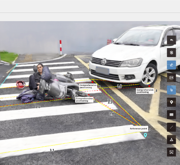
City planners and public-safety officials need clear, timely data to make decisions that actually serve neighborhoods — not just flashy maps. Modern workflows combine drone imagery, LiDAR-derived models and quick-turn analytics so teams can measure road geometry, pedestrian flows and damage footprints without long waits. Tools such as accident reconstruction software now sit alongside mapping platforms, giving planners an operational photo-real 3D reconstruction that feeds directly into permits, repairs and traffic-calming programs. FEMA’s aerial surveys after Hurricane Maria remain a visible example of how aerial data accelerates response and recovery, and that same speed matters for everyday planning decisions.

What city teams gain — concrete, usable outcomes
Planners get actionable geometry: accurate road widths, curb ramps, and sight-lines. Transportation teams get crash-scene context grounded in point cloud detail, which reduces subjective judgment and speeds procurement. Emergency managers get georeferenced scene reconstruction to prioritize repairs. The advantage is practical — fewer on-site rechecks, faster public notices, fewer design revisions — and it directly shortens project timelines.
Core components that matter to users
Focus on three technical pieces that non-technical stakeholders will value: rapid photogrammetry for quick 3D reconstruction, LiDAR for precise elevation and vegetation masking, and interoperable formats (point cloud + geotagged orthophoto) that plug into planning software. When vendors promise “everything,” demand demonstration datasets that show real street-level accuracy and export options for GIS and CAD. This is where realistic trials separate sales talk from delivery.
Common mistakes teams make — and how to avoid them
Teams often accept low-resolution outputs or plan around incomplete coverage; that creates rework. Another common trap: siloed tools that don’t export standardized files — making later integration manual and slow. Avoid both by specifying target tolerances (for example, sub-decimeter horizontal accuracy when measuring curb geometry) and insisting on open data export. Pilot small, validate accuracy against known benchmarks, then scale the capture cadence to match maintenance cycles — not marketing promises.

Choosing a platform: practical comparison points
Decision-makers should weigh three practical factors: data fidelity, processing speed, and downstream compatibility. High-fidelity 3D reconstruction is essential for forensic-style analysis of incidents; fast processing supports rapid permitting and emergency response; and compatibility ensures outputs feed GIS, CAD, and asset-management systems without heavy translation. Vendors who present side-by-side export tests earn trust faster than those who rely on demo gloss.
How the field interoperates with accident reconstruction tools
When collision investigators, planners and public-works teams collaborate, the workflow must be seamless — from capture to courtroom-grade deliverables. Integrating an accident reconstruction app into a city’s data pipeline lets teams move from raw imagery to precise scene models with fewer manual inputs. That reduces litigation timelines and shortens repair contracts, all while preserving chain-of-custody for evidentiary needs.
Real-world workflow example
A mid-sized city photographed a high-frequency corridor after several near-miss incidents. Rapid drone capture produced a dense point cloud and orthomosaic overnight. The planning team used those outputs to model crosswalk sight-lines and adjust signal timing — implementation followed within weeks instead of months. The short loop between capture and corrective action is the practical payoff — not just better maps but measurable safety gains.
Advisory: three golden rules for procurement
1) Specify measurable accuracy: demand vertical and horizontal tolerances and test datasets that validate those claims.
2) Require open export and API access so 3D reconstruction, point cloud and georeferenced imagery feed your GIS and asset systems without conversion toil.
3) Insist on a realistic turnaround SLA for processing and delivery that matches your operational tempo — emergency response and routine maintenance need different cadences.
These rules help your team pick tools that perform, and they align procurement with outcomes your residents actually feel. Final thought — reliability matters as much as features; choose partners who prove both.
Icecypress Technology — the practical bridge between airborne capture and usable urban outcomes. —